 |
ac9wzn00000245
NAVIGATION FUNCTION
id092000101300
Outline
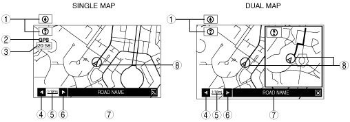
Map Screen Selection
Current position map
ac9wzn00000245
|
|
No. |
Contents |
Description |
|---|---|---|
|
1
|
Map orientation
|
North up
• Geographic north is up.
Head up
• The direction you are heading is up.
|
|
2
|
GPS reception indicator
|
Illuminates when receiving signals from 3 or more satellites.
|
|
3
|
Clock
|
Clock will be displayed when set using the navigation screen.
|
|
4
|
Zoom in button
|
Enlarges the map. (more detail)
|
|
5
|
Map scale
|
The map can be displayed in 13 steps with scale from 50 m to 256 km {1/32 mile to 128 mile}
|
|
6
|
Zoom out button
|
Reduces the map.
|
|
7
|
Road name
|
Shows the name of the road you are currently driving on.
|
|
8
|
Vehicle position
|
Shows the current position and direction of the vehicle.
|
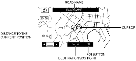
Scroll map mode
ac9wzn00000246
|
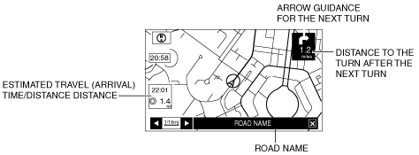
Guide mode
ac9wzn00000247
|
Intersection zoom map
ac9wzn00000248
|
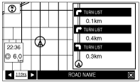
Turn list
ac9wzn00000249
|
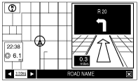
Turn arrow
ac9wzn00000250
|
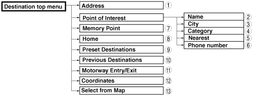
Destination Setting Function
Outline
ac9wzn00000251
|
|
No. |
Contents |
|---|---|
|
1
|
Sets destination by inputting address.
|
|
2
|
Sets destination by inputting POI name.
|
|
3
|
Sets destination by selecting POI city, inputting city name and selecting POI.
|
|
4
|
Sets destination by selecting POI category, inputting target name and selecting POI.
|
|
5
|
Sets destination by inputting POI nearest facility.
|
|
6
|
Sets destination by selecting POI phone number, inputting phone number and selecting POI.
|
|
7
|
Sets destination from a list of points stored by the user.
|
|
8
|
Sets destination to home.
|
|
9
|
Sets destination to preset destination point.
|
|
10
|
Sets destination from a list of recent destinations.
|
|
11
|
Sets destination by selecting Motorway Entry / Exit.
|
|
12
|
Sets destination by inputting coordinates.
|
|
13
|
Sets destination by moving the crosshair cursor to the destination when in scroll map mode.
|
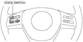
Voice Recognition Function
ac9wzn00000252
|