CAR-NAVIGATION UNIT FUNCTION
id092000117800
Outline
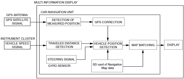
• The navigation system is a hybrid type system which combines independent navigation (detection of current position using gyro sensor and vehicle speed signal) and satellite navigation (detection of current position using signal form GPS satellite). In addition, highly accurate detection of the current position is provided based on map matching which identifies the current position by comparing the map information data read from the navigation map data on the SD card with the current position measured by the independent navigation and satellite navigation systems.
• Calculates route to destination, and provides guidance using maps and voice guidance.
Structure
Independent navigation
• To detect the vehicle's current position, the car-navigation unit processes the orientation data obtained from the gyro sensor and the vehicle speed signal obtained from the instrument cluster and performs a cumulative calculation of the vehicle orientation and traveled distance. Based on this, highly accurate detection of the vehicle's current position is possible even if a GPS signal is not available.
• A part of the orientation detection data utilizes signals from GPS.
Gyro sensor
-
― The relative orientation (the vehicle's orientation relative to the direction in which it is advancing) is detected from the vehicle's steering angle.
Vehicle speed signal
-
― The car-navigation unit calculates the vehicle's traveled distance based on the vehicle speed signal output from the instrument cluster.
-
Note
-
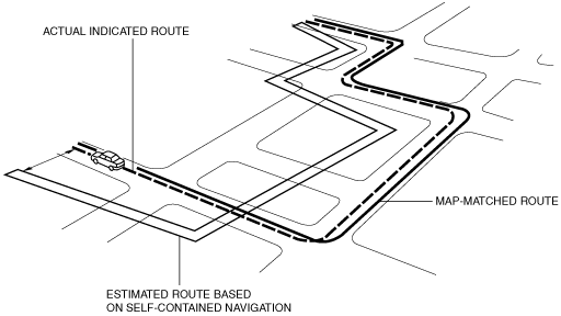
• There are cases, as indicated below, in which the current vehicle position cannot be detected due to the occurrence of differences between the actual vehicle speed and the vehicle speed signal from the instrument cluster. In these cases, the current position is corrected frequently using the GPS navigation or map matching.
-
― Type of tire used is changed (such as size)
― Tire air pressure is not inflated to specification
― Vehicle is driven on snow, gravel or other slippery type road
― Tire chains are installed
Satellite navigation
• The current position is detected based on the signal received from GPS.
GPS (Global Positioning System)
-
― GPS is a navigation system developed by the U.S. Department of Defence. The system has GPS satellites orbiting the earth at an altitude of approximately 21,000 km {13,000 miles}.
― There are at least five satellites over any point 24 hours a day.
― The navigation unit receives radio signals from these satellites and determines a vehicle's position.
Map Matching
• This function compares the route shape the vehicle is travelling to map data using the GPS satellite signals, and corrects the vehicle's position to the most appropriate road on the map data.
Guidance
Display guidance
• Distance remaining to destination, branch points, and road names are displayed on the display.
Voice guidance
• Remaining distance to destination, branch points and direction names are provided via voice guidance.Voice guidance is output through the vehicle speakers.