NAVIGATION FUNCTION [TYPE B]
id092000101331
Outline
• A vehicle's position is measured by a hybrid method of autonomous navigation (using yaw-rate signals from the gyro sensor and vehicle speed signals from the instrument cluster) and GPS navigation (using signals from GPS satellites). Accurate detection of the vehicle's position is possible based on the adoption of a map-matching function which specifies the vehicle's position as compared with the map data read from the DVD-ROM and the vehicle's position measured from autonomous navigation and GPS navigation.
• Guidance to destination is provided via display of the recommended route on the map screen, as well as voice messaging guidance at intersections and points of divergence.
• RDS-TMC system has been adopted.
• Based on inputted signals and information on the DVD-ROM, the following features are available:
-
- Destination can be selected based on address, POI (Point of Interest), postcode, memory point, home, preset destination, junction, motorway Ent/Exit, coordinates, map or previous destination.
-
- Route information is available in map, turn list, turn arrow, enlarged junction diagram, motorway information mode.
-
- Voice guidance and menus are available in twelve languages.
-
- A map screen that displays maps in thirteen steps with scales from 50 m to 256 km.
-
- A map screen that displays routes according to Search condition and route preferences.
Search condition
-
Quick: The route with the quickest time will be used.
-
Altern.: The alternative route will be used.
-
Short: The route with the shortest distance.
Route preferences
-
Allow Major roads
-
Allow toll road
-
Allow restricted road
-
Allow ferry
-
Allow car train
Map Screen Selection
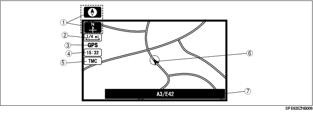
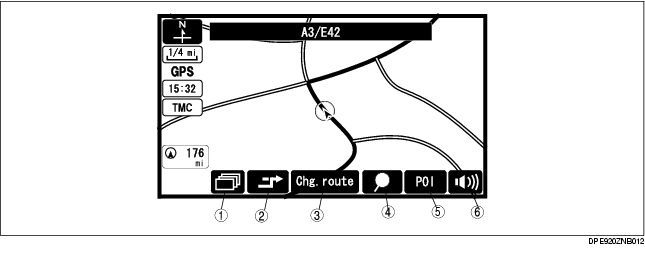
Current position map
-
• The location of the vehicle and surrounding area are shown.
.
|
No.
|
Contents
|
Description
|
|
1
|
Map orientation
|
North up
• Geographic north is up.
Head up
• The direction you are heading is up.
|
|
2
|
Map scale
|
The map can be displayed in 13 steps with scale from 50 m {1/32 ml} to 256 km {128 ml}
|
|
3
|
GPS reception indicator
|
Illuminates when receiving signals from 3 or more satellites.
|
|
4
|
Clock
|
Clock will be displayed when you set up clock on navigation set up on.
|
|
5
|
TMC icon
|
Shown on the display when there is TMC station reception.
|
|
6
|
Vehicle position
|
Shows the current position and direction of the vehicle.
|
|
7
|
Road name
|
Shows the name of the road you are currently driving on.
|
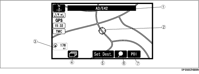
Scroll map mode
-
• The scroll map is displayed when operating the joystick on the current position map.
-
• This map can be scrolled with the crosshair cursor.
.
|
1
|
Road name
|
|
2
|
Crosshair cursor
|
|
3
|
Distance to the current position
|
|
4
|
Display mode button
|
|
5
|
Destination/via point button
|
|
6
|
Mark point button
|
|
7
|
POI button
|
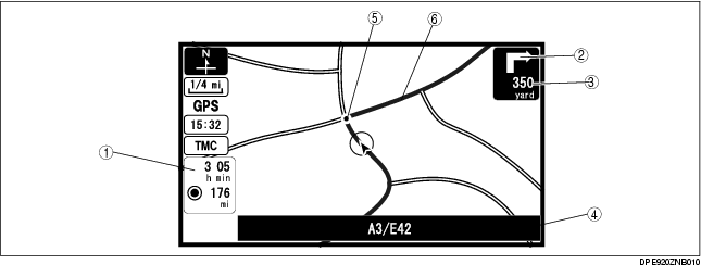
Guide mode
-
• Displays an arrow guidance to indicate destination, and also displays route and destination guidance information. (While in route guidance.)
.
|
1
|
Estimated travel (arrival) time/Destination distance
|
|
2
|
Arrow guidance for the next turn
|
|
3
|
Distance to the next turn
|
|
4
|
Road name
|
|
5
|
Guidance point
|
|
6
|
Route display
|
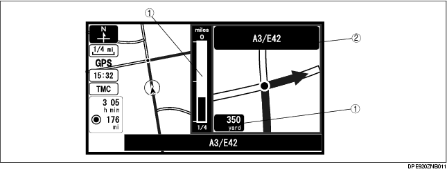
Intersection zoom map
-
• An enlarged map is displayed when approaching a roundabout or intersection. (While in route guidance.) Activated by selecting Guidance Screen (On) in setup mode.
.
|
1
|
Distance to the next turn
|
|
2
|
Next road name
|
Pop Up Menu
• Pop up menu appears when pressing the [ENTER] button.
• The following items are displayed on the pop up menu. The actual displayed items vary according to whether the destination has been set or not.
.
|
No.
|
Contents
|
Description
|
|
1
|
Display configuration
|
The following items can be selected.
• single or dual map
• Turn list
• Turn arrow
• Enlarged junction diagram
• Motor way information
|
|
2
|
Detour
|
Searches for detour.
|
|
3
|
Change route
|
Changes route search settings.
|
|
4
|
Store memory point
|
Stores markers on the map.
|
|
5
|
POI (Point of Interest) display
|
Displays POI on the map.
|
|
6
|
Volume
|
Adjusts volume of voice guidance.
|
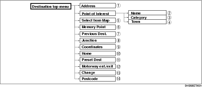
Destination Setting Function
Outline
-
• The following instructions explain how destinations can be chosen and set.
-
Note
-
• A destination can be set to where the crosshair cursor indicates by selecting the Destination option of the scroll map mode pop-menu.
.
|
No.
|
Contents
|
|
1
|
Sets destination by inputting address.
|
|
2
|
Sets destination by inputting POI name.
|
|
3
|
Sets destination by selecting POI category, inputting target name and selecting POI.
|
|
4
|
Sets destination by selecting POI category, inputting city name and selecting POI.
|
|
5
|
Sets destination by moving the crosshair cursor to the destination when in scroll map mode.
|
|
6
|
Sets destination from a list of points stored by the user.
|
|
7
|
Sets destination from a list of recent destinations.
|
|
8
|
Sets destination by selecting junction name.
|
|
9
|
Sets destination by inputting coordinates.
|
|
10
|
Sets destination to home.
|
|
11
|
Sets destination to preset destination point.
|
|
12
|
Sets destination by selecting Motorway ent./exit.
|
|
13
|
Changes search area.
|
|
14
|
Sets destination by inputting postal code.
|
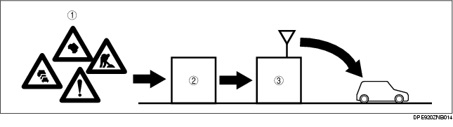
RDS-TMC Function
• The Traffic Message Channel (TMC) is a specific application of the Radio Data System (RDS) used for broadcasting real-time traffic and weather information.
• The TMC icon is shown on the display when there is TMC station reception.
|
1
|
Traffic messages
|
|
2
|
Traffic information center (TIC)
|
|
3
|
Radio broadcast station
|
TMC (Traffic Massage Channel) icon function
-
• The color which are related to the events are described in the following table.
|
Color
|
Description
|
|
Red
|
Stationary traffic
|
|
Orange
|
Traffic jam
|
|
Pink
|
• Accidents
• Road works
• Danger (disaster information)
|
|
Black
|
Closed road
|
|
Yellow
|
• Road conditions
• Weather
• Delays (delays by the stationary/queuing traffic)
|
|
Gray
|
Out of order (other than those above)
|